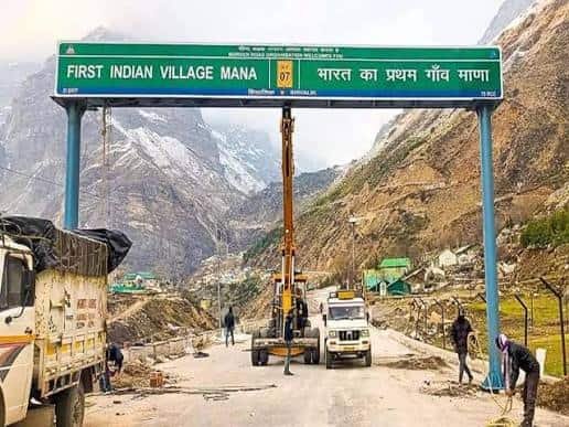
Just a few kilometres from Badrinath, at the very edge of the Indo-Tibetan border, Mana carries the title “India’s Last Village” — a distinction that draws pilgrims, trekkers, and curious travellers up into the Chamoli district’s high Himalayan reaches every summer. Home to the Bhotia community and steeped in Mahabharata-linked mythology, Mana sits at an altitude that keeps it snowbound for much of the year, opening its doors to visitors only during a short, intense tourist window.
Mana Village Overview
| Detail | Information |
| Location | Chamoli district, Uttarakhand, near the India-Tibet border |
| District | Chamoli |
| Altitude | Approx. 3,200 metres |
| Distance from Badrinath | Approx. 3–4 km |
| Distance from Joshimath | Approx. 45–50 km |
| Distance from Rishikesh | Approx. 300 km |
| Known For | “India’s Last Village” title, Vyas and Ganesh Caves, Saraswati River origin |
| Notable Sites | Bheem Pul, Vasudhara Falls, Mata Murti Temple |
| Best Time to Visit | May to October (closed in winter due to snow) |
The Village at the Edge of the Country
Mana sits at roughly 3,200 metres in the upper Alaknanda valley, just beyond Badrinath, in a stretch of Uttarakhand so close to the Tibet border that the village has long carried strategic as well as spiritual significance. Its population, predominantly from the Bhotia community, has traditionally practised transhumance, migrating to lower altitudes each winter as snow renders the village uninhabitable.
- Local tradition holds that Mana was where sage Ved Vyas composed the Mahabharata with Lord Ganesha as scribe, and the village’s Vyas Cave and Ganesh Cave remain important pilgrimage sites tied to this legend.
- The Saraswati River is believed to originate near Mana before disappearing underground close to its confluence with the Alaknanda, adding to the village’s mythological weight.
- Mana’s residents relocate to lower-altitude towns during the harsh Himalayan winter, meaning the village is genuinely active and inhabited only for a portion of the year, typically aligning with the Char Dham pilgrimage season.
How to Reach Mana Village
Reaching Mana means first reaching Badrinath, since the village sits just a short distance beyond it along a road that itself sits among the higher motorable stretches in the Indian Himalayas.
By Road
- The journey typically routes through Rishikesh and Joshimath, covering roughly 300 km from Rishikesh, a drive that usually takes 10–12 hours depending on road and weather conditions.
- From Badrinath, Mana is just 3–4 km away, connected by a short, well-used road that most pilgrims and tourists cover by shared taxi, private vehicle, or on foot.
- Roads in this high-altitude stretch can be affected by landslides or snow outside the main travel season, so checking conditions before setting out is essential.
By Rail
- Rishikesh Railway Station is the nearest major rail link, connecting to Delhi, Haridwar, and other parts of North India, with the remaining journey to Mana covered entirely by road.
By Air
- Jolly Grant Airport in Dehradun, the nearest airport, offers limited domestic connectivity, mainly from Delhi, with the onward journey to Mana requiring several hours of mountain driving via Rishikesh and Joshimath.
What’s Around Mana: Attractions and Pilgrimage Sites
Mana’s small size belies the density of significant sites packed into its immediate surroundings, most tied to Hindu mythology and the region’s spiritual geography.
Nearby Attractions
- Bheem Pul, a massive natural rock bridge said to have been placed by Bhima during the Pandavas’ journey, spans the Saraswati River just outside the village and remains one of Mana’s most photographed sites.
- Vasudhara Falls, a scenic waterfall reachable via a moderate trek from Mana, draws both pilgrims and trekkers for its dramatic setting amid the high mountains.
- Mata Murti Temple, dedicated to the mother of the Badri Vishal deity, lies close to Mana and is often visited alongside the village’s other pilgrimage stops.
Practical Facilities
- Basic guesthouses, dhabas, and tea stalls operate in Mana during the tourist season, though facilities remain simple given the village’s remote, high-altitude setting.
- Most visitors base themselves in Badrinath, given its more developed accommodation options, and visit Mana as a short excursion.
Why Mana Continues to Draw Pilgrims and Trekkers
Mana’s pull lies in its rare combination of geographic extremity, deep mythological association, and proximity to one of Hinduism’s most important pilgrimage sites.
- Its status as “India’s Last Village” gives visitors a tangible sense of reaching the country’s literal edge, a draw in itself for many travellers.
- The concentration of Mahabharata-linked sites within a short walking distance makes Mana a compelling stop for pilgrims already visiting Badrinath.
- Its high-altitude Himalayan setting, framed by peaks and the Saraswati and Alaknanda rivers, offers striking scenery that continues to draw trekkers and photographers each season.
Frequently Asked Questions
Q1. When is the best time to visit Mana village?
May to October is ideal, coinciding with the Char Dham pilgrimage season; the village is inaccessible and largely uninhabited during winter due to heavy snowfall.
Q2. How far is Mana from Badrinath, and can it be visited on foot?
It’s just 3–4 km away, and many pilgrims walk the stretch, though shared taxis are also readily available.
Q3. Do I need any special permits to visit Mana given its border location?
Indian citizens generally don’t require special permits to visit Mana itself, though it’s worth checking current regulations before travel, as areas closer to the actual border may have restrictions.
Q4. Are ATMs or medical facilities available in Mana village?
Facilities are very basic; most visitors handle banking, medical needs, and major provisions in Badrinath or Joshimath before heading to Mana.